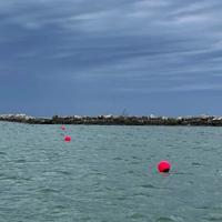
ASHTABULA – The U.S. Army Corps of Engineers (USACE), Buffalo District, marked a submerged rock wall with red buoys inside the eastern breakwater of Ashtabula Harbor.
Boaters are now alerted to the 1,500 linear foot wall by nine red buoys with reflective tape, floating at water level approximately every 165 feet. The top of the submerged stone wall is about one to two feet below water level.
The wall creates an enclosed space not designed for boater access. For safety reasons, boaters must remain within the boundaries of the federal shipping channel until outside the harbour.
“It’s very important that boaters be alert and cautious while on this part of the lake,” County Commissioner Casey Kozlowski said.
The wall forms an L-shape, following the same southeasterly direction as the outermost segment of the eastern breakwater, for approximately 1,000 feet toward the shore. It then curves east towards the inner part of the east breakwater for about 500 feet.
The submerged stone wall was built in 2021 as a site for dredging sediment, creating a new wetland ecosystem. The project is expected to significantly improve the condition of Ashtabula Harbor for native plants and animals, as well as area residents and waterfront visitors, and is being carried out in close coordination with the Port Authority of Ashtabula. Ashtabula City, the Ohio Environmental Protection Agency and the Ohio Department of Natural Resources.
Ashtabula City Council Chairman John Roskovics said he hoped the wall would not become a problem during the shipping season.
“I hope everyone will follow the Corps’ instructions and advice,” he said. “Boating is too important in our region, so we must respect this area and ensure a safe season for all.”
James Carkhuff of Jack’s Marine in Ashtabula said he was glad the Army Corps of Engineers had clearly marked the wall.
“The harbor is a busy place, thanks to good walleye fishing,” he says.
Details of this project and important safety information have been shared with local marinas, boat launches and angler hubs, as well as a Local Notice to Mariners (LNM), issued by the US Coast Guard. The USACE also provided the National Oceanographic and Atmospheric Administration with coordinates and design data for the submerged rock wall to include on their current navigational charts.
Comments are closed.